What is the Issue?
We are concerned that the scale and mass of the building envelopes are excessive, both in relation to the Pyrmont peninsula and to the low scale of Glebe on the western side of the Bay.
Jones Street clifftop walk
Foreshore open space adjacent to Blackwattle Bay Park.
What can you do?
- Your voice counts – make a submission on the proposed Blackwattle Bay by Friday, 20 August 2021.
- Read the Trust’s key points below to inform your submission. ·
- Make your submission at www.planningportal.nsw.gov.au/blackwattlebay
What are the Trust concerns about the proposal?
- We are concerned that the scale and mass of the building envelopes are excessive, both in relation to the Pyrmont peninsula and to the low scale of Glebe on the western side of the Bay.
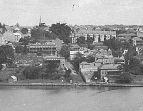
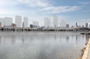
The proposal to allow 12 building envelopes, each of up to 45 storeys high (approx. 156m) along the waterfront will create a wall of development, blocking the harbour from the rest of Pyrmont. This is higher than the Anzac Bridge as well as any other building west of Pyrmont Bridge at Darling Harbour. Earlier community surveys indicated 92% pf people surveyed felt that any new built form in the area should reflect the low rise character of the Glebe and Pyrmont areas.
Buildings of this height and in this narrow space will visually dominate Blackwattle Bay, crowd the Anzac Bridge (whose pylons are 120m tall), obstruct views and vistas to and from the Pyrmont Peninsula, and create a wall of buildings that will alter the perception of the urban morphology and the remnant historic cultural landscape.
- We are concerned about significant overshadowing cast by the towers across Wentworth Park, the Bay itself and the public areas.
The towers will cast shadows along the proposed public domain including the public waterfront promenade, making it unpleasant particularly in winter. This is a poor approach to place-based planning and is not what our iconic harbour and Pyrmont deserve. Good design should locate any tall buildings in locations on the Peninsula that optimise solar access in public spaces, in particular places for public recreation and the foreshore.
The excessive building envelopes and heights result in excessive shadowing of the bay and the proposed public spaces. Mornings are a key time for water sports on Blackwattle Bay, harbourside walks, and visits to the fish markets. Having towers that throw these areas into shadow is bad urban design and will reflect poorly on the significant investment in the new fish market whose roof and harbourside platforms are designed specifically to engage with the sunlight of the bay.
- We are concerned that good placemaking principles are being ignored by the development not responding to the existing character and scale of the area.
At its core, placemaking seeks to build on existing character, meaning and identity – something that Pyrmont and adjacent Glebe can offer in abundance.
A building of 45-51 storeys does not complement the Pyrmont Peninsula heritage character, or the overall low to medium rise character across the peninsula and nearby Glebe (with noted recent intrusions and exceptions at Jacksons Landing and Darling Harbour).
Pyrmont Peninsula’s major commercial, entertainment, residential and retail buildings sit comfortably with terrace housing, smaller shops and heritage areas. They benefit from the area’s proximity to the CBD but also the character and charm of surrounding buildings and public domain. Any changes in building forms and public domain must be sympathetic to, or enhance, that character, rather than dominate and block it out.
- We are concerned that heritage considerations have been completely sidelined.
The Blackwattle Bay State Significant Planning Study’s Masterplanning Principles include ZERO reference to the existing heritage and character of the area, despite there being detailed earlier heritage studies of the area. One such study, the Pyrmont Peninsula Place Strategy’s Heritage Study (GML Heritage, 2020) recommended that new development on Pyrmont Peninsula should not dominate or compete with eth horizontal landform of the peninsula, and that it should be respectful and consistent with the character of the area in terms of its scale, form, rhythm and materiality.
The Heritage Impact Statement for the SSP proposal fails to adequately assess the cumulative impact of the development on the peninsula’s overall heritage value, it fails to assess the impact on nearby heritage conservation areas, it does not address the impact of the tower height on the landmark values of the ANZAC Bridge.
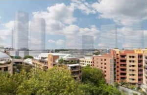
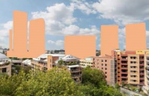
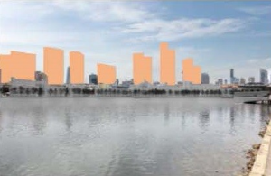
- We are concerned that the Visual Impact Assessment does not adequately represent the impact of the proposed development.
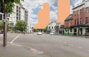
Visual Impact Assessments should be objective, independent assessments of proposed developments. As very few people have been trained to “translate” building plans or to decipher detailed technical studies (such as the 49 technical studies and addendums on exhibition for this proposal), a picture tells a thousand words and is a critical tool that should clearly show the extent of a development and its impact.
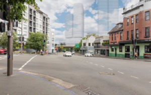
In this context, it t is interesting to consider whether the use of an extremely light transparent blue to portray the proposed buildings unreasonably softens the impression of their impact (see Images below to illustrate this).
The data in Visual Impact report lacks objectivity. For instance, it states that “the majority of the visual impacts fall within the negligible to moderate scale (eleven viewpoints), with nine
viewpoints registering a moderate/high to high rating.” However, this simple statement collates the data by grouping three datasets (low, moderate-low, and moderate) against only two datasets (moderate-high, high). Should the visual impact continue to feel the need to group data, it should be consistently grouped to enable a more objective presentation of its findings, for example:
- 9 important viewpoints have moderate-high or high, impact from the development;
- 3 important viewpoints have moderate impact from the development; and
- 6 important viewpoints have moderate-low or low impact from the development.
When grouped consistently, a different picture emerges from the data.
- We are concerned that Sydney City Council will not be the determining authority
The best planning outcomes come when the public can provide input and when decisions are made by those who represent affected communities.
There is a proposal to declare Blackwattle Bay a public authority precinct like Barangaroo and Darling Harbour which would enable the state government to design and deliver public domain areas and manage future use of the site outside normal transparent and accountable planning processes. This will be the case regardless of building ownership. This approach undermines the purpose of determining areas of state significance, risking social licence for major development.
Blackwattle Bay must be subject to local government planning and management to ensure all decisions are open, transparent and accountable, and reflect community input.
Pocket Park at Gipps Street near Harris Street Heritage Conservation Area
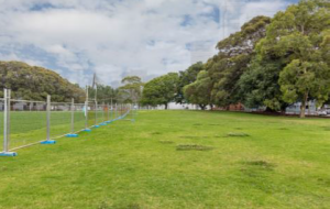
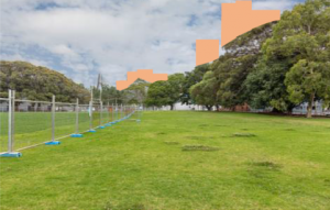
View from Wentworth Park
Read More
 Facebook
 Linkedin
 Email
Email